Although we had a great time living the high life at the
resort, Beth and I were both missing our little trailer after 3 days of
separation and there was a small buzz of excitement as we hooked her up,
farewelled Uluru, Yulara and Kata Tjuta and headed along the black top (4WD’er
jargon for bitumen) bound for Kings Canyon in Wattarka National Park.
King’s Canyon’s main claim to fame is the Rim Walk which
climbs the canyon wall on one side then takes you along that rim, down into the
canyon, across the other side and back along the other rim. Needless to say there is spectacular scenery
aplenty along the route. We enjoyed it
so much that we did it twice. We also
took the opportunity to cover about half of the Ernest Giles walking track
which links the gorges within Wattarka National Park. Plenty of rocks to clamber over, some of
which were reminiscent of the Bungle Bungles “beehive” formations, which got
Beth quite excited. All this walking
helped to bolster our daily average, which had suffered somewhat during our
hedonistic Yulara interlude. Thankfully
we are back on track now.
Whist in Yulara, a Melbourne based friend couldn’t help but
inform me (gleefully I think) of the pitiful performance of my football team
whilst I have been away. I didn’t really
need the update because despite our remoteness, I seem each week to have been
able to get radio reception of each excruciating loss to date. I replied to my friend that I was well
appraised of my team’s performance, and that to allay my pain I would ensure
that when next they played that I would be in so remote a location that I would
be beyond torment. King’s Canyon ticked
all the boxes. No radio reception at
all, no phone coverage, no internet, and seemingly no real interest in football. Unfortunately, some greater power must have
observed some poor behaviour on my part during my team’s glory years, and
decided that I had not yet served a reasonable penance for that behaviour. I should have seen the satellite dish on the
roof of the King’s Canyon Hotel and walked away despite the strong inducement
of coffee. Instead I entered the bar and
of course was confronted by live coverage of my hapless team being put to the
sword by the former worst team in the competition. Despite my obvious pain I remained transfixed
for half an hour during which time I made a silent promise to never again gloat
about my team or to taunt supporters of lesser performing teams. Despite the natural grandeur of this place, I
think King’s Canyon will be best remembered by me as the place where it was
confirmed that my football team was a basket case.
From King’s Canyon to Palm Valley (in the Finke River
National Park) involves a gravel road (the Merinee Loop) which has been
signposted as closed due to flood damage.
This of course is not what we want because the only alternative is to
back track and potentially miss Palm Valley, which we have both been looking
forward to visiting. Before heading off
we check at the garage, and are told that there are some wash aways in the
Merinee Loop and a bit of water, but it is fine for 4WD vehicles driven
cautiously. The state of the Palm Valley
road however was less clear, and we were advised to enquire about that further
down the track. Beth of course nominated
herself as the cautious driver (unfair aspersions on me I think) and handled
the few tricky bits on the road through to Hermannsburg (where the Palm Valley
road starts) with aplomb. Although there
were no signs indicating the Palm Valley road was closed we decided to extend
our caution and visit the old Hermannsburg Lutheran Mission site to enjoy
refreshments (out of town signposts promising excellent scones had seduced me)
and check conditions. As we were walking
into the township we happened upon a NT outback policeman, and thought who
better to ask about road conditions.
When we mentioned the Palm Valley road his brow furrowed a little and he
asked what sort of vehicle we had. I pointed
to the Jeep whereupon his countenance changed.
“You’ll have no problems at all getting the Jeep in there” said the
policeman with a smile. This made me
very happy because in these parts our Jeep is a very minor species amongst the
Toyota Land Cruisers and the Nissan Patrols and I get the sense that they are
not quite trusted as a bona fide 4WD. So
any affirmation of capability comforts me, but one from an outback policeman
gives me great joy.
Beth again took the reins for the journey into Palm Valley,
and apart from some bumpy spots and quite a lot of crossings of the Finke River
(some moderately deep) the first sixteen kilometres to the campground were
quite uneventful. A misunderstood sign
at the campground (navigator sits in the passenger seat so I guess that would
be my fault) meant that we missed the turnoff, but we realized our mistake
quite quickly and resolved to turn around at the next opportunity. As we rounded the next bend there was a 4WD
parked across the road and a park ranger standing with his hand
outstretched. He had obviously spotted
us from a distance and performed a Starsky and Hutch roadblock manoeuvre to
ensure that we did not take our trailer the last 4 km into the valley. “The
Jeep is OK to go into the valley, but I don’t think you should take the trailer
in”, he muttered. Despite our assurances
that we had just missed the turn, I sensed that this poor chap generally had
the job of retrieving the broken vehicles of people who have overestimated the
capabilities of themselves and their vehicles, and his demeanour suggested that
we were just another couple of those. We
duly followed his instructions, turned around and this time took the campground
turnoff, set up the trailer and took a lovely walk up into the rocks around the
campground.
The next day after another walk amongst the rocks it was
time to venture forth that last 4 kilometres into the valley – without the
trailer of course. We have been into
Palm Valley before on a 4WD tour, and my recollection was that there were quite
a few rocky obstacles to overcome, so I was looking forward to the challenge
with a little bit of nervous excitement.
Given that Beth had got us here in one piece it was probably fair that
she got to drive in (it also allowed me to cheat a little bit on the way
out). The drive was every bit as
exciting as I remember, with the addition of a bit more water to the equation
given the height of the Finke River. Once again both Beth and the Jeep were very
impressive, and the old adage of “ask a policeman” was proven right. A walk through beautiful Palm Valley, which
is filled with ancient red cabbage palms which are unique to this valley and
have somehow managed to survive in this place since prehistoric times, and we
are off again, this time for a couple of nights in the big smoke of Alice
Springs.
No real sightseeing in Alice Springs, our main purpose here
is to reprovision and carry out some running repairs. This of course meant a visit to both Bunnings
and Supercheap Auto, two of my favourite holiday destinations. I was very happy with this, but Beth was less
enthusiastic, so my joy was fairly short lived.
We also managed the daunting task of ridding our vehicles of the red
muck accumulated over the preceding weeks.
Although they are now showing their true colours, there is still plenty
of red dust and mud lurking in hard to get to nooks and crannies. I think when we get home a whole day needs to
be set aside for car cleaning. Despite
the utilitarian Alice Springs agenda, we still managed a couple of nice long
walks (one at the start of the Larapinta Trail) and we did enjoy being in
something resembling a city again.
The next part of our journey involves getting some miles
under our belt to get to our next significant destination (Nitmiluk National
Park – Better known as Katherine Gorge) which is still well over 1,000
kilometres away. In years gone by we
would have just jumped in the car and done this in a day, but thankfully we
have grown out of that and now rate the journey as much as the destination, so
our intention is to take 3 days with overnight stops at Devil’s Marbles
Conservation Park and Daly Waters along the way.
Having just said that the journey is as special as the
destination, I am still trying to figure out what was special about the stretch
of The Stuart Highway between Alice and Devil’s Marbles, but Devil’s Marbles
was quite enchanting and we really enjoyed wandering amongst and climbing upon
the rocks.
The next section of The Stuart Highway was almost as
featureless, but the monotony was somewhat broken up by a few more road houses
and the township of Tennant Creek where we found an open café (this was Easter
Saturday) boasting excellent cupcakes.
The coffee was good, but the cake did not live up to its billing. Enjoyable nonetheless. Tennant Creek is an interesting town, I believe
that it grew as a mining town, but these days the predominant employer seems to
be the public service. Police, Courts,
Centrelink and Medical Services are prominent.
There is a permanent police station, but there was also a mobile police
station set up (in the centre of the road near the pub), and we counted at
least 5 police vehicles patrolling the town.
I think that this is all a bit of a sad reflection on how we have
managed the cultural differences between Europeans and our indigenous folk over
the years. Despite the current sad state
of affairs, I do sense that there is greater understanding of and respect for
aboriginal culture and aboriginal people than there has been in the past. This is definitely the case at places like
Uluru, where there is a buck to be made from aboriginal culture, but it also
seems obvious in the attitudes of police officers here in Tennant Creek, which
is good news. Sadly though, I think that
there is still a huge disconnect between the values of white Australians and
Indigenous Australians, and despite great efforts and intentions, the future
for Indigenous people trying to live their values within their culture seem to
me to be quite bleak.
As well as more settlements on this stretch of road there
are also more signs of life, strangely enough most evidenced by the road kill,
which around here seems to be predominately cattle. I now know why a bull bar is so named. I think in the stretch between Tennant Creek
and Daly Waters we must have passed 20 dead cows, presumably the night time
victims of the enormous road trains which thunder along this road. The other thing that we are seeing more of
along the road is termite mounds, some of which travellers have taken to
dressing in t-shirts, hats and even sunglasses.
The first of these that I encountered almost caused me to pull over and
see if they needed assistance. Interesting
and useless fact I learnt about termites.
Evidently the total biomass of termites in the Northern Territory is
greater than the total biomass of all cattle in Australia. Imagine if insects were able to marshal
themselves as a cohesive force against humans.
We would have no chance.
After a tough day counting road kill and termite mounds, we
rolled into Daly Waters intent on staying at the caravan park attached to the
famous Daly Waters Pub. We were little
surprised by the number of people at and around the pub, but didn’t think too
much of it and proceeded to the counter to book a site. The young girl behind the counter looked a
little bewildered and said, “You really do not want to be staying here
tonight”. It transpires that Easter
Saturday is the date for the Daly Waters B&S (Bachelors and Spinsters) Ball,
which young folk come from far and wide to attend and presumably drink
themselves silly in a very noisy fashion and generally make fools of
themselves. After a few foolish seconds
of thinking that it might be fun to observe these antics we came to our senses
and agreed with the girl behind the bar and back tracked a few kilometres to a
more sedate camp site where we enjoyed a peaceful night.
Next stop Nitmiluk, which we have heard really good things about
and are both eagerly anticipating. The
beauty of this place is extraordinary, but must be enjoyed at a leisurely pace and
with liberal sprinklings of cooling off in pools and air conditioned coffee
breaks. The heat and humidity here is
quite energy sapping, and whilst Beth seems to be coping with it reasonably
well, I have to admit I am struggling.
To make sure that we get our kilometres in we are continuing
our strategy of early morning walking to beat the heat of the day and spending
the afternoon in the pool. This is
working OK, but it seems to get hot and sticky here as soon as the sun
rises. Despite the climate, the walks
that we have done here have been immensely enjoyable. The vegetation is incredibly diverse and
quite beautiful, and the landscape rugged and spectacular, particularly the
river gorges. Because there is still a
bit of water about the river is quite high and we have been lucky enough to
enjoy some waterfalls and flowing streams as well as the river.
Whilst the walks have been fantastic, so has the cooling off
and socialising in the pool. Because we
have spent 5 nights at the caravan park we have seen many people come and go
and have enjoyed chatting with a set of tourists as diverse as the vegetation
here (Belgians, French, Spanish, Dutch, Queenslanders and other
foreigners). This has definitely been
the most sociable caravan park that we have encountered, mainly I think because
the pool attracts everybody and becomes a social hub. On our last full day at Nitmiluk we treated
ourselves to a fantastic boat cruise through the gorges to give ourselves a
different perspective than we enjoyed from our walks. During this cruise we bumped into a family
from just out of Geelong (which of course is Beth’s home town) and discovered
that they actually occupied the site next to us in the caravan park. We met again in the pool and chatted until we
were wrinkled like prunes. The children
(Sienna and Charlie) kept us entertained that evening as well, making each of
us a bracelet with the kits they had received as Easter gifts, and which I
believe are all the rage. Beth and I
have been proudly wearing our bracelets in the hope that people will stop and
stare and murmur such things as “Wow”, “Cool”, or “Sweet”. It hasn’t happened yet, but it is early days
and we live in hope. We really enjoyed
the company of this family and were especially impressed with the nature of the
kids, who were considerate, clever and capable and made us feel a little bit
special, which was great. One of the great
things about this trip is the number of really nice people we have met,
particularly young people. We often hear
tales of woe regarding our young folk and grim tidings regarding the future of
the world, but as I see it we are in pretty good hands.
Next stop is Kakadu where we spend 5 nights. Reports are half the park is closed at the
moment due to recent rains and high water levels. This means that some roads are impassable,
but more importantly, effective crocodile management has not been possible in
some places. Rest assured we will not be
taking any chances with crocs.
I have talked at length about our walking targets, some of
the beautiful (and not so beautiful) walks we have completed, and how we go about
managing our walks according to weather, but I haven’t really given you the
anatomy of our walks yet. For those of
you heartily sick of hearing about walking, perhaps you should close this page
now and I will see you at my next blog instalment. All others please read on.
You will perhaps not be surprised to hear that generally our
walks are well researched and meticulously planned, but very occasionally they
can also be impromptu (although these do cause Beth some anxiety, particularly
if a map cannot be secured). Regardless
of the type of walk there are common tools, protocols and rules that we
observe, and you will probably also not be surprised to learn that we each have
distinct roles which we perform.
Before we embark on a walk Beth insists on having a map
which she commits to memory before we head off.
Despite taking this mental picture, she still prefers a paper map which
she can roll up in the shape of a baton and clutch in her left hand as she walks
to use both as a pointer and something to be pondered over and cursed over at
tricky bits on the trail. Where a paper
map cannot be secured, it is my job to photograph the maps painted on signs so
that we can refer to and curse at the camera at these tricky spots.
Backpacks are loathsome burdens which we try to avoid, but
on some walks the carrying of provisions and other paraphernalia makes them a
necessary evil. Very rarely though do we
need to carry more than one between the two of us. Although Beth often volunteers to do the
toting, there seems to be a vestige of machismo in me which insists that I
should be the beast of burden.
Like all athletes we have our little pre game rituals that
we carry out. We empty shoes of debris,
inspect socks for burrs and prickles, swap orthotics from shoe to shoe, take a
long drink (I generally take a small snack as well – which typically induces
frowns), apply bandages, slop on lotions of every description, clean our glasses, adjust our walking poles etc. etc.
When we set out Beth will almost always assume the role of
lead and navigator. Whilst you may
assume that this implicates Beth as a control freak, it is nothing of the sort. Any of you who know my spectacularly poor
sense of direction will understand the folly in allowing me to take the
lead. Beth’s leadership is a practical
necessity borne not out of a control instinct, but a survival instinct.
I follow along, from time to time offering inane advice
regarding directions (which is duly ignored), but generally sticking to my role
as official photographer. This following
is a whole lot more difficult than you might imagine. Beth is a little like a diesel locomotive,
she starts out slowly, but then she settles on a steady speed and holds it
regardless of terrain. I on the other
hand am a little more akin to a bicycle ridden by an overweight elderly
gentleman, I move relatively quickly
downhill (albeit unsteadily), and need to be dismounted and pushed slowly with
much puffing and wheezing uphills.
Combine this inconsistent speed with my propensity to be consumed by
photographic subjects from time to time, and it is not an unusual thing for me
to lose touch with my good wife, which means that I need to either run to catch
up or meet her at the next map pondering point (not because she is perplexed
and needs my advice, but because she knows I will get lost is she does not
wait. One thing that works in my favour
here is that Beth seems to be outrageously incompetent at keeping her shoelaces
tied. She ties them tightly, then does
the double knot, but you can guarantee that within a kilometre they will have
come loose. Lace tying is one thing at
which I excel, and the infrequency of my need to re-tie laces relative to Beth
does help me to catch up. Despite these difficulties we seem to make
things work, and more importantly we enjoy the experience and accept the
differences. (Is likening my wife to a
diesel locomotive an indication that I am secure in my relationship, or is it
just foolish I wonder??)
As well as official photographer, I also hold the important
role of official archivist. My children
gave me a GPS sports watch for Christmas, which was intended to map and keep
track of my jogging exploits, but it has now been pressed into service to
record all our walks. From time to time
limitations of the technology (and occasionally my forgetfulness) means that
our walks have not been officially mapped, but by and large all our walks have
been GPS tracked and recorded on an internet based data store and mapping tool,
which is pretty cool.
One last note before
I sign off. Some of you have told me
that you are unable to add comments to my blog.
I am sure that there is a technical widget that I need to tweak to make
this happen, but I am afraid I cannot readily find it. So if you feel the need to make a comment or
(perish the thought) suggest a correction or seek a retraction, please send an
email to bethandmarkjohnson@gmail.com
, we would love to hear from you.
Until next time…..
Another one I know - but I cannot help myself - I love Uluru

Kings Canyon - Rim Walk

Kings Canyon - Rim Walk
Hermannsburg Mission

Rock Climbing - Finke River NP

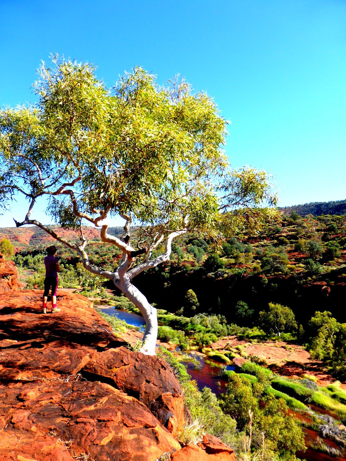
Finke River NP - Outlook

Rock climbed - Finke River NP

Rocks - Finke River NP

Red Cabbage Palms - Finke River NP

Finke River NP - Outlook

Survival - Finke River NP

Palm Valley - Finke River NP
Palm Valley - Finke River NP

Palm Valley - Finke River NP

Alice Springs - Telegraph Station

The Devil's Marbles

The Devil's Marbles

Beth Surveying her domain - Devil's Marbles

Tennant Creek - Telegraph Station

God's fingers touching the landscape - Nitmiluk NP

Beth taking a shower - Nitmiluk NP

Nitmiluk NP

Water Lilies - Nitmiluk NP

Dragonfly on water lily bud - Nitmiluk NP

Turtle - Nitmiluk NP

Katherine River - Nitmiluk NP

Crow Butterfly - Nitmiluk NP

Wildflowers of Nitmiluk NP

Our bracelet gifts


